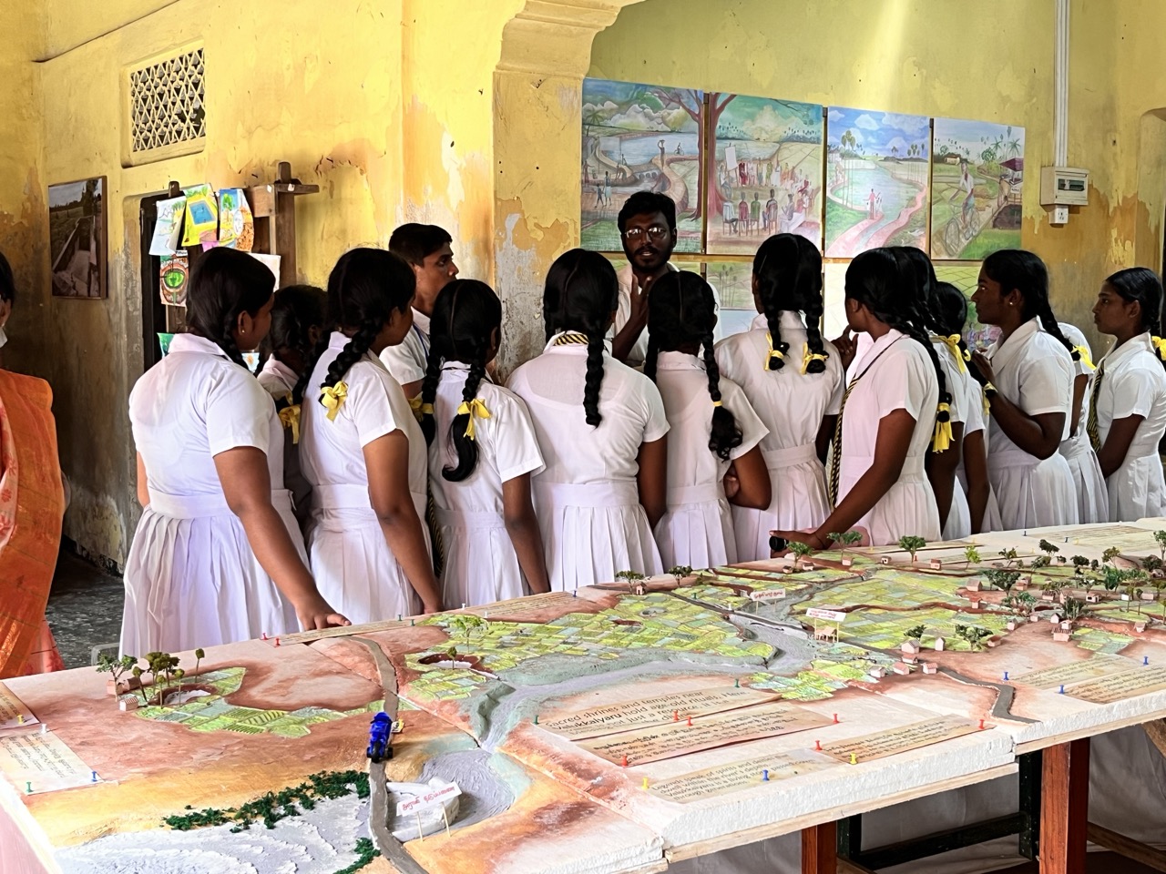
The crowds at the Nallur festival converge for many reasons. Many will be there to get a divine glimpse, tharisanam, of Kanthan, the Tamil god of war, resplendent on his chariot, with Raavanan as his charioteer. Others will be there for the carnival buzz, to people watch, spoilt for choice among 200,000 fellow revellers, or to make the most of the market stalls peddling everything from the famous thiruvizha peanuts to children’s toys and hair accessories, as well as the local businesses handing out freebies. Last year, among the exhibitors vying for the attention of the crowds were a small group of researchers, displaying a model of a river just 10km away. For most of the stall’s visitors, though, it may as well have been 1000km away.

The river, Vazhukkai Aaru, is a seasonal river system originating near Thellippalai and flowing south through Valikamam, finally discharging at the Araly Barrage. It functions primarily as a monsoon-fed drainage channel, collecting runoff from an extensive catchment area covering the ancient Valikamam region. During the monsoon season, generally three months long beginning in October, ponds and irrigation tanks within this region fill with rainwater, and the surplus overflows into Vazhukkai Aaru. Historically, this natural hydrological system helped prevent flooding, contributed to groundwater discharge and sustained agriculture in the region.

Today, the river is fading, and with it the memory of a sophisticated waterscape that was once integral to the daily lives of the residents of the mostly agricultural lands in the region. During the prolonged armed conflict, the Vazhukkai Aaru system was severely disrupted, with many ponds, feeder channels and natural drains degraded due to neglect or blocked by the Sri Lankan military forces in order to construct security bunds and military earthworks. In later years, these areas were levelled with no effort to restore the original water pathways, resulting in the loss of both the integrity of the catchment and the flow path of the river itself.

​Vazhukkai Aaru is just one of many traditional water storage systems that the North is losing to war and its after effects, from mass migration to overdevelopment - both commercial and residential. Unlike the post-war revival around cultural phenomena such as the Nallur festival, which sees Jaffna heaving beyond its capacity every summer, environmental preservation and revival have seen far fewer advocates. While the Tamil polity mobilises consistently against militarisation and land-grabs, the environmental repercussions of these threats remain a fringe concern in popular campaigning.

​The group of researchers exhibiting at Nallur, WASPAR, are part of an effort to increase consciousness of water insecurity both institutionally and societally in the North. The WASPAR project, Water Security through Participatory Action Research, focuses on promoting sustainable water use and collective decision-making based on evidence in Tamil communities. The group works on linking social and environmental science to advocate for integrated water resource management by linking surface water, groundwater, land use and climate variability within a single planning approach. The project also convenes Young Water Professionals (YWP), bringing together engineers, environmental scientists, planners and researchers, creating a space for inter-sectoral conversations to address post-conflict water challenges. Vazhukkai Aaru, which is now almost impossible to trace to an untrained eye, is an emblematic case study for the project.

​To someone unfamiliar with the area, the landscape does not immediately resemble a river system at all. Yet among long-time residents of the surrounding villages, there remain memories of a very different landscape. Older members of the community recall when ponds filled first during the monsoon, before water gradually moved through natural channels across the fields. Locals understood where water would collect, how it would flow through the land, and which areas were meant to hold it. Within a single generation, much of this understanding has faded. How did a landscape that once managed water so carefully begin to forget it?

​This question lies at the centre of WASPAR, whose research has gradually evolved from a technical investigation into a process of listening to the community and recovering the fragments of knowledge that remain embedded in the landscape. Many residents of the Valikamam villages still remember the ponds that were used for irrigation or livestock, while others filled seasonally during heavy rains. Fields would hold water for a short time before draining through natural pathways. Seasonal flooding was once a predictable part of the agricultural cycle.

​Farmers adapted their cropping patterns to rainfall cycles, choosing varieties that could tolerate wetter or drier conditions. Wells were often shared between neighbouring households, and decisions about water use were shaped by informal cooperation. Residents closely observed rainfall patterns, and agricultural decisions were guided by their long-term experiences of working the land. Maintaining the ponds was a routine, collective task carried out before each monsoon season. Sediment would be cleared and channels kept open so that water could flow freely through the system. Across Valikamam, the seasonal flows of Vazhukkai Aaru connected communities through this network of ponds and fields. Rainwater falling in one part of the catchment would gradually move through the landscape before eventually reaching the sea.

​More than its forgotten river, Valikamam is known for being home to Vaddukkoddai, renowned across the Tamil landscape for its political significance. In 1976, the town became the site of the Vaddukkoddai Resolution, a political declaration that called for the creation of a separate Tamil state. The adoption of the resolution was a pivotal moment in Tamil political history, and its values continue to inform and anchor Tamil political struggle. Armed conflict disrupts the relationship between people and land, but few realise how the landscape in which this political history unfolded is shaped by its relationship to water. The same villages where political meetings were held were connected by the ponds, wells and seasonal waterways of Vazhukkai Aaru. Farmers who participated in political movements also depended on the delicate water systems that sustained their livelihoods.

While headlines focused on destroyed houses and communal buildings, less obvious were the ponds that had disappeared or the drainage channels that had been blocked or overgrown.

​During the war, large parts of the Valikamam region were declared and remain High Security Zones by the Sri Lankan Army, restricting residents’ access to farmland and water. Entire communities were displaced, leaving ponds untended and drainage channels blocked. Some water bodies were deliberately altered or filled as part of military earthworks and security infrastructure. When residents eventually returned after years, even decades, of displacement, they found the landscape radically altered. While headlines focused on destroyed houses and communal buildings, less obvious were the ponds that had disappeared or the drainage channels that had been blocked or overgrown.

​As well as the neglect and destruction of the past, the post-war period has brought a different set of challenges. Road networks have expanded, new buildings have appeared, and development has accelerated across the peninsula, pushed forward by successive Sri Lankan regimes in place of meaningful political solutions. The Jaffna peninsula has also begun to experience a different kind of transformation. Diaspora investment has started flowing into residential construction, with new houses, boundary walls and paved compounds appearing across neighbourhoods whose layouts once prioritised porosity to the adjoining paddy fields.

​Locals complain that these developments often prioritise aesthetic preferences and modern designs, while the environmental functions that traditional architecture performed have been overlooked or forgotten. In former agricultural regions across Jaffna, ponds are filled to create level building plots and drainage paths are blocked by roads, walls or raised foundations. The result is a landscape that looks prosperous and modern in many places, yet functions very differently from the ecological systems that previously sustained it.

Within this changing environment, Vazhukkai Aaru, where it has even been mentioned, gradually came to be described primarily as a drainage channel rather than a complex seasonal water system. The earlier understanding of the river as both a storage and drainage system has slowly faded from both public and institutional awareness. WASPAR’s community conversations reveal how fragmented knowledge about the system has become. In some discussions, the very existence of the river is questioned. In others, the relevance of restoring ponds is challenged, in favour of fast solutions such as tube wells, with little thought for the exploitative and potentially damaging effects of these methods of water extraction, including groundwater depletion and salinisation.

The WASPAR project approaches these challenges through Participatory Action Research, emphasising collaboration and dialogue between researchers and communities. The work begins by walking the landscape, with field visits across the Vazhukkai Aaru basin, which have revealed numerous ponds that are now abandoned, partially filled or functioning far below their original capacity. Many have not been maintained or desilted for decades. Equally important are the conversations that occur during these visits. Residents share recollections of how water once moved across the land, while farmers describe changing rainfall patterns and shifting agricultural practices.

The operational team involved in this work are mainly young Tamil women, doing everything from mapping the water pathways, to convening the YWP forums and interviewing impacted communities. Their presence sometimes feels anomalous in spaces traditionally dominated by elder, male voices. However, when asked about the dynamics of working in male-dominated fields, the young women themselves are quick to play down any hint of complaint, although admitting that many Tamil families may not support young women travelling across the region and interacting substantially with ‘strangers’ to carry out fieldwork. One researcher stressed that their focus has always been on building trust with communities, distinguishing themselves from foreign researchers whose methods they describe as often extractive or insensitive. Instead, the members of the WASPAR team harness their relatability to the communities they engage with, becoming another daughter to the families and ensuring that conversations about water become accessible to everyone involved and impacted.

The annual Nallur festival, where this story began, became one of the most significant spaces for sharing these conversations. What started in 2024 as a simple exhibition-style stall turned into something much more powerful the following year. Over the course of fifteen days, the group curated a series of cultural displays with the support of colleagues and friends from the University of Jaffna and wider artistic networks. Performances included the koothu (street dance-drama), folk singing, and classical Carnatic music and Bharatanatyam, all exploring themes of water, rainfall and traditional stewardship of the land. Encountering the story of Vazhukkai Aaru and water systems like it not only through maps and models but through music, dance and storytelling traditions, unlocked for many deep cultural memories of their own relationship with land and water. Alongside the performances, the model of the river basin helped visitors visualise how ponds, fields and drainage paths once connected villages across the catchment. Most importantly, the display introduced the idea that the seasonal flooding and groundwater problems that residents of the peninsula experience today might be connected to changes in the wider landscape.

Map by Johnathan Subendran

Historically, communities across the Jaffna peninsula managed water collectively through shared ponds and seasonal practices. Today, water management is increasingly individualised through tube wells, tanker deliveries and centralised supply systems. This shift introduces broader questions about water sovereignty and the capacity of communities to maintain control over their own water resources. In a region where debates about political autonomy have long been central, the issue of water governance should be inseparable from discussions about land, livelihood and self-determination. Participatory research helps open these conversations, advocating for solutions which respect local and traditional knowledge. The WASPAR group hopes that through their community engagement, forgotten water pathways and traditional practices will re-enter public awareness. The young researchers spearheading these efforts aim to act as bridges between generations, linking scientific analysis and innovation with lived memory.

YWP initiatives have included catchment mapping, preliminary water audits, community consultations and awareness programmes on groundwater protection, flood risk reduction and climate resilience. Special attention has been given to areas such as Valikamam, where, despite its appearance as a lush region of paddy fields and irrigation canals, decades of neglect have resulted in environmental degradation, altered drainage systems and increasing flood events.

Standing in the villages of Valikamam today, it is still difficult to see the river that once flowed through it. The disappearance of this system did not happen suddenly. It unfolded gradually through decades of social and economic change. The armed conflict displaced entire communities from the peninsula for long periods, disrupting the bonds between people and land. Many families were displaced internally or overseas, and when some eventually returned, the agricultural routines that once structured village life had already begun to unravel. In the post-war period, economic opportunities remain limited, encouraging further migration and a turn away from traditional livelihoods. Younger generations increasingly seek opportunities overseas or in the towns. As agriculture continues to decline, many of the ponds, channels and seasonal water pathways that supported it are left untended, or worse, destroyed to make way for development projects.

Through research, community dialogue and cultural engagement, Vazhukkai Aaru may be slowly returning to collective awareness, but this rediscovery is unfolding at a moment when the region faces new environmental pressures. Climate change is already altering rainfall patterns across the Jaffna peninsula. Monsoon rains have become more erratic, sometimes arriving in intense bursts that overwhelm the altered drainage system and produce sudden flooding. In other years, prolonged dry periods strain groundwater supplies and intensify salinity intrusion into wells. The peninsula’s fragile freshwater lens, always vulnerable because of the limestone geology and proximity to the sea, is particularly sensitive to these changes. When heavy rainfall cannot be stored in ponds and wetlands, it runs quickly to the sea rather than recharging groundwater. When dry periods lengthen, over-extraction from tube wells, a short-term saviour but a long-term disaster, further destabilises the balance between fresh and saline water beneath the land.

Adapting to a changing climate means finding solutions old and new, as well as mobilising every community that lives, works or passes through the Jaffna peninsula, and the wider Tamil homeland. Yet any discussion of environmental protection in the North must also confront a difficult truth. While development has been the carrot and the stick used by post-war Sri Lanka in its attempts to fragment Tamil national and environmental politics, it cannot simply be discouraged in a region that has endured decades of deliberate destruction and underdevelopment. The challenge, therefore, is not development itself, but the absence of coordinated planning capable of balancing growth with ecological sustainability. Without such planning, individual decisions such as whether to drill a new well, fill a pond to build a house, or pave a courtyard, gradually accumulate into systemic environmental destruction.

WASPAR advocates for a centralised and integrated water management strategy for the North, moving away from treating water as a series of isolated technical problems, such as flooding in one village and groundwater depletion in another. Such an approach would recognise the interdependence of surface water, groundwater, land use and climate variability, and place watershed planning at the centre of regional development policy. Restoring ponds, protecting drainage pathways, and managing groundwater extraction would no longer be ad hoc responses, but part of a coordinated effort to sustain the peninsula’s fragile water systems. Centralised management should not mean replacing community knowledge with bureaucratic control, although it would require a concerted effort to bring together local environmental memory, scientific research and public policy within a shared framework. The farmers, residents, engineers and hydrologists that WASPAR convene all have a role to play in shaping how water is governed in the future.

In many ways, the story of Vazhukkai Aaru reflects the broader trajectory of the peninsula itself as a landscape marked by loss, transformation and resilience. The river that once flowed past Vaddukkoddai became invisible not because it disappeared overnight, but because the relationships that sustained it were violently disrupted and gradually unravelled. If the future of Jaffna is to be both prosperous and sustainable, it will require rediscovering how to safeguard its water.